File:Singapore MRT and LRT System Map.svg
Jump to navigation
Jump to search

Size of this PNG preview of this SVG file: 800 × 571 pixels. Other resolutions: 320 × 229 pixels | 640 × 457 pixels | 1,024 × 731 pixels | 1,280 × 914 pixels | 2,560 × 1,828 pixels | 1,410 × 1,007 pixels.
Original file (SVG file, nominally 1,410 × 1,007 pixels, file size: 59 KB)
Captions
Captions
Add a one-line explanation of what this file represents
Summary[edit]
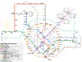
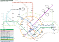
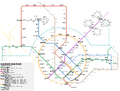
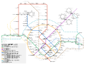
| Description |
Bahasa Melayu: Peta Sistem Pengangkutan Gerak Cepat (MRT) dan Transit Aliran Ringan (LRT) di Singapura.
中文:新加坡地铁与轻轨系统图 (英文版) |
| Date | |
| Source | Own work |
| Author | Aforl. |
| Other versions |
|
| SVG development | This W3C-invalid map was created with an unknown SVG tool. This map is translated using SVG switch elements: all translations are stored in the same file. |
Licensing[edit]
I, the copyright holder of this work, hereby publish it under the following license:
This file is licensed under the Creative Commons Attribution-Share Alike 3.0 Unported license.
- You are free:
- to share – to copy, distribute and transmit the work
- to remix – to adapt the work
- Under the following conditions:
- attribution – You must give appropriate credit, provide a link to the license, and indicate if changes were made. You may do so in any reasonable manner, but not in any way that suggests the licensor endorses you or your use.
- share alike – If you remix, transform, or build upon the material, you must distribute your contributions under the same or compatible license as the original.
File history
Click on a date/time to view the file as it appeared at that time.
| Date/Time | Thumbnail | Dimensions | User | Comment | |
|---|---|---|---|---|---|
| current | 06:40, 25 November 2022 | | 1,410 × 1,007 (59 KB) | Aforl (talk | contribs) | Correct minor typo |
| 06:37, 25 November 2022 |  | 1,410 × 1,007 (59 KB) | Aforl (talk | contribs) | TEL3 opening, updated legend | |
| 04:25, 19 November 2022 |  | 1,410 × 1,007 (107 KB) | Officer781 (talk | contribs) | Remove TEL 3 from list as it has been implemented | |
| 20:19, 18 November 2022 |  | 1,410 × 1,007 (107 KB) | Pyzirikov (talk | contribs) | Updated Thomson-East Coast Line | |
| 07:46, 8 October 2022 |  | 1,410 × 1,007 (59 KB) | Aforl (talk | contribs) | TEL3 opening date announced | |
| 10:28, 20 September 2022 |  | 1,410 × 1,007 (59 KB) | Aforl (talk | contribs) | CRL2 Announced, DTL3e opening year updated | |
| 16:27, 27 August 2021 |  | 1,410 × 1,007 (58 KB) | Aforl (talk | contribs) | TEL2 opens | |
| 10:21, 23 July 2021 |  | 1,410 × 1,007 (58 KB) | Aforl (talk | contribs) | Update opening dates/years | |
| 13:22, 27 November 2020 |  | 1,410 × 1,007 (58 KB) | Aforl (talk | contribs) | + TEL2 opening (Q1 2021) Modify PE to CPE | |
| 05:15, 31 July 2020 |  | 1,410 × 1,007 (58 KB) | Aforl (talk | contribs) | Updated RTS Link Opening Year |
You cannot overwrite this file.
File usage on Commons
More than 100 pages use this file. The following list shows the first 100 pages that use this file only. A full list is available.
- Mass Rapid Transit (Singapore)
- User:Aforl
- User:Chumwa/OgreBot/Potential transport maps/2016 April 21-30
- User:Chumwa/OgreBot/Potential transport maps/2016 December 21-31
- User:Chumwa/OgreBot/Potential transport maps/2016 July 21-31
- User:Chumwa/OgreBot/Potential transport maps/2016 June 11-20
- User:Chumwa/OgreBot/Potential transport maps/2016 March 11-20
- User:Chumwa/OgreBot/Potential transport maps/2016 March 21-31
- User:Chumwa/OgreBot/Potential transport maps/2016 May 21-31
- User:Chumwa/OgreBot/Potential transport maps/2016 October 21-31
- User:Chumwa/OgreBot/Potential transport maps/2017 April 1-10
- User:Chumwa/OgreBot/Potential transport maps/2017 April 21-30
- User:Chumwa/OgreBot/Potential transport maps/2017 June 1-10
- User:Chumwa/OgreBot/Potential transport maps/2017 June 11-20
- User:Chumwa/OgreBot/Potential transport maps/2017 October 21-31
- User:Chumwa/OgreBot/Potential transport maps/2018 January 21-31
- User:Chumwa/OgreBot/Potential transport maps/2018 May 1-10
- User:Chumwa/OgreBot/Potential transport maps/2018 May 11-20
- User:Chumwa/OgreBot/Potential transport maps/2019 January 1-10
- User:Chumwa/OgreBot/Potential transport maps/2019 January 21-31
- User:Chumwa/OgreBot/Potential transport maps/2019 March 1-10
- User:Chumwa/OgreBot/Potential transport maps/2019 March 11-20
- User:Chumwa/OgreBot/Public transport information/2015 August 11-20
- User:Chumwa/OgreBot/Public transport information/2015 December 21-31
- User:Chumwa/OgreBot/Public transport information/2015 July 11-20
- User:Chumwa/OgreBot/Public transport information/2015 October 21-31
- User:Chumwa/OgreBot/Public transport information/2015 September 11-20
- User:Chumwa/OgreBot/Public transport information/2016 April 21-30
- User:Chumwa/OgreBot/Public transport information/2016 December 21-31
- User:Chumwa/OgreBot/Public transport information/2016 July 21-31
- User:Chumwa/OgreBot/Public transport information/2016 June 11-20
- User:Chumwa/OgreBot/Public transport information/2016 March 1-10
- User:Chumwa/OgreBot/Public transport information/2016 March 11-20
- User:Chumwa/OgreBot/Public transport information/2016 March 21-31
- User:Chumwa/OgreBot/Public transport information/2016 May 21-31
- User:Chumwa/OgreBot/Public transport information/2016 October 21-31
- User:Chumwa/OgreBot/Public transport information/2017 April 21-30
- User:Chumwa/OgreBot/Public transport information/2017 June 1-10
- User:Chumwa/OgreBot/Public transport information/2017 June 11-20
- User:Chumwa/OgreBot/Public transport information/2017 October 21-31
- User:Chumwa/OgreBot/Public transport information/2018 January 21-31
- User:Chumwa/OgreBot/Public transport information/2018 May 1-10
- User:Chumwa/OgreBot/Public transport information/2018 May 11-20
- User:Chumwa/OgreBot/Public transport information/2019 January 1-10
- User:Chumwa/OgreBot/Public transport information/2019 January 21-31
- User:Chumwa/OgreBot/Public transport information/2019 March 1-10
- User:Chumwa/OgreBot/Public transport information/2019 March 11-20
- User:Chumwa/OgreBot/Public transport information/2019 May 21-31
- User:Chumwa/OgreBot/Transport Maps/2015 August 11-20
- User:Chumwa/OgreBot/Transport Maps/2015 December 21-31
- User:Chumwa/OgreBot/Transport Maps/2015 July 11-20
- User:Chumwa/OgreBot/Transport Maps/2015 October 21-31
- User:Chumwa/OgreBot/Transport Maps/2015 September 11-20
- User:Chumwa/OgreBot/Transport Maps/2016 April 21-30
- User:Chumwa/OgreBot/Transport Maps/2016 December 21-31
- User:Chumwa/OgreBot/Transport Maps/2016 July 21-31
- User:Chumwa/OgreBot/Transport Maps/2016 June 11-20
- User:Chumwa/OgreBot/Transport Maps/2016 March 1-10
- User:Chumwa/OgreBot/Transport Maps/2016 March 11-20
- User:Chumwa/OgreBot/Transport Maps/2016 March 21-31
- User:Chumwa/OgreBot/Transport Maps/2016 May 21-31
- User:Chumwa/OgreBot/Transport Maps/2016 October 21-31
- User:Chumwa/OgreBot/Transport Maps/2017 April 1-10
- User:Chumwa/OgreBot/Transport Maps/2017 April 21-30
- User:Chumwa/OgreBot/Transport Maps/2017 June 1-10
- User:Chumwa/OgreBot/Transport Maps/2017 June 11-20
- User:Chumwa/OgreBot/Transport Maps/2017 October 21-31
- User:Chumwa/OgreBot/Transport Maps/2018 January 21-31
- User:Chumwa/OgreBot/Transport Maps/2018 May 1-10
- User:Chumwa/OgreBot/Transport Maps/2018 May 11-20
- User:Chumwa/OgreBot/Transport Maps/2019 January 1-10
- User:Chumwa/OgreBot/Transport Maps/2019 January 21-31
- User:Chumwa/OgreBot/Transport Maps/2019 March 1-10
- User:Chumwa/OgreBot/Transport Maps/2019 March 11-20
- User:Chumwa/OgreBot/Transport Maps/2019 May 21-31
- User:Chumwa/OgreBot/Travel and communication maps/2016 April 21-30
- User:Chumwa/OgreBot/Travel and communication maps/2016 December 21-31
- User:Chumwa/OgreBot/Travel and communication maps/2016 July 21-31
- User:Chumwa/OgreBot/Travel and communication maps/2016 June 11-20
- User:Chumwa/OgreBot/Travel and communication maps/2016 March 1-10
- User:Chumwa/OgreBot/Travel and communication maps/2016 March 11-20
- User:Chumwa/OgreBot/Travel and communication maps/2016 March 21-31
- User:Chumwa/OgreBot/Travel and communication maps/2016 May 21-31
- User:Chumwa/OgreBot/Travel and communication maps/2016 October 21-31
- User:Chumwa/OgreBot/Travel and communication maps/2017 April 1-10
- User:Chumwa/OgreBot/Travel and communication maps/2017 April 21-30
- User:Chumwa/OgreBot/Travel and communication maps/2017 June 1-10
- User:Chumwa/OgreBot/Travel and communication maps/2017 June 11-20
- User:Chumwa/OgreBot/Travel and communication maps/2017 October 21-31
- User:Chumwa/OgreBot/Travel and communication maps/2018 January 21-31
- User:Chumwa/OgreBot/Travel and communication maps/2018 May 1-10
- User:Chumwa/OgreBot/Travel and communication maps/2018 May 11-20
- User:Chumwa/OgreBot/Travel and communication maps/2019 January 1-10
- User:Chumwa/OgreBot/Travel and communication maps/2019 January 21-31
- User:Chumwa/OgreBot/Travel and communication maps/2019 March 1-10
- User:Chumwa/OgreBot/Travel and communication maps/2019 March 11-20
- Commons:Graphic Lab/Map workshop/Archive/2010
- File:Singapore MRT & LRT System Map.png
- File:新加坡地铁与轻轨系统图.svg
- File:新加坡地铁与轻轨系统路线图.png
View more links to this file.
File usage on other wikis
The following other wikis use this file:
- Usage on af.wikipedia.org
- Usage on en.wikipedia.org
- Usage on en.wikivoyage.org
- Usage on es.wikipedia.org
- Usage on fa.wikipedia.org
- Usage on fi.wikipedia.org
- Usage on id.wikipedia.org
- Usage on it.wikipedia.org
- Usage on ja.wikivoyage.org
- Usage on lt.wikipedia.org
- Usage on ms.wikipedia.org
- Usage on nl.wikipedia.org
- Usage on ru.wikipedia.org
- Usage on simple.wikipedia.org
- Usage on th.wikipedia.org
- Usage on tr.wikipedia.org
- Usage on vi.wikipedia.org
- Usage on www.wikidata.org
- Usage on zh-yue.wikipedia.org
- Usage on zh.wikipedia.org